Urban Flood Resilience (system dynamics model)
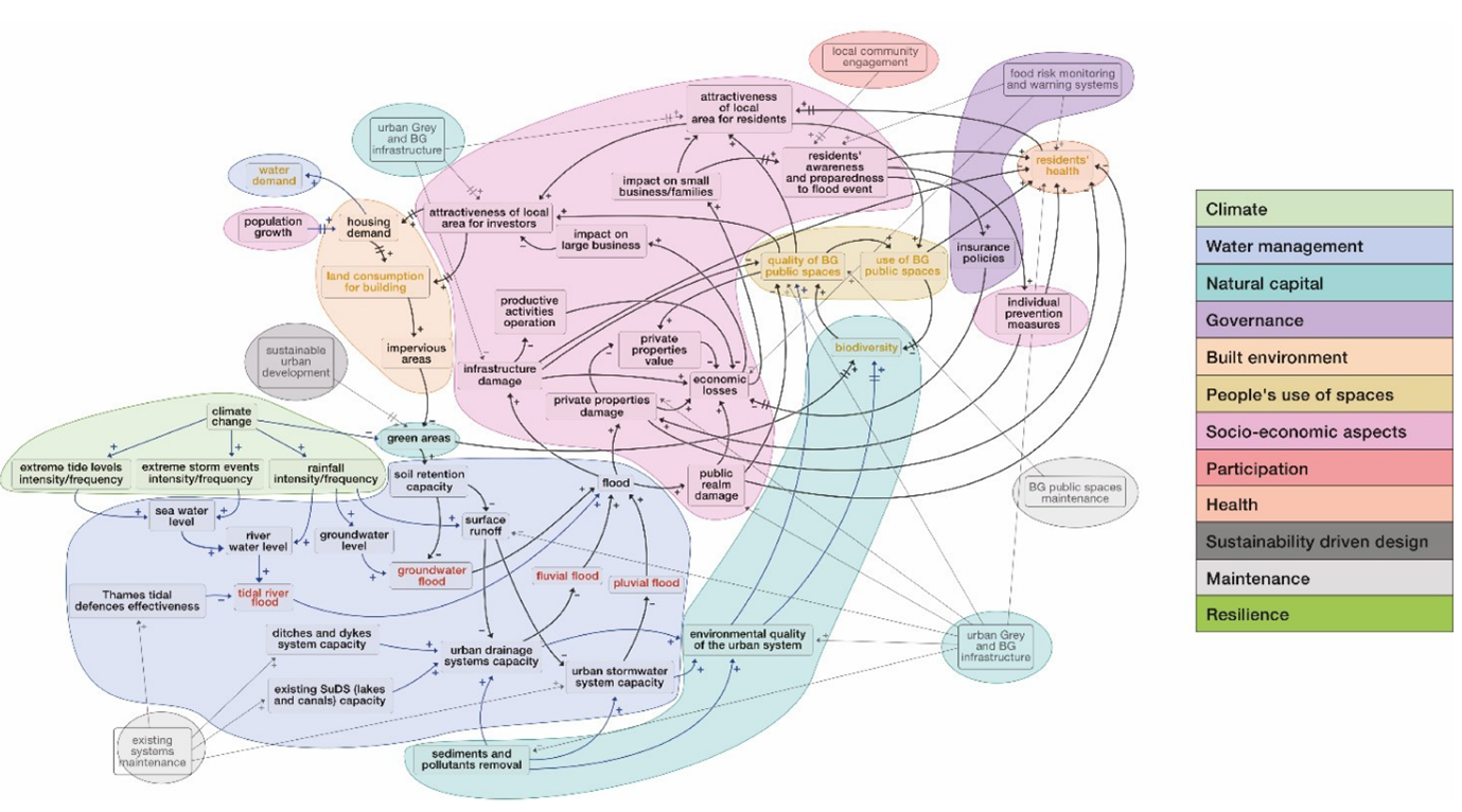
A flood risk System Dynamics (SD) model aiming at supporting decision-makers in enhancing urban flood resilience in Thamesmead (London, United Kingdom).
UCL Team
Author
Contact UCL Team
Email
Project website
Details
Thamesmead is a neighbourhood in South-East London, currently undergoing a process of urban regeneration. Thamesmead is a former inhospitable marshland, drained in the 1960s when the Greater London Council decided to transform the reclaimed land into a residential area. Therefore, the area is vulnerable to four types of flooding mechanisms: tidal, fluvial, pluvial, and groundwater flood.
The main objective of the simulation model is to provide useful information for decision-makers at a strategic level to increase the level of flood resilience in Thamesmead. This model combines a simplified flood estimation model with other sectoral models (such as the effects of climate change and population growth) to explore alternative urban pathways. It enables: a) understanding on how qualitative and quantitative aspects interact and influence the urban system; b) systematic exploration of a very large number of possible future scenarios; c) provision of useful information at a planning or strategic level.

This modelling approach was adopted due to its capacity of building a holistic system picture, while allowing an evaluation of different management solutions and identification of suitable strategies for both flood risk reduction and urban resilience increase. The conclusions of the work are as follows:
- SD modelling provides a broader view of the urban system and allows comparisons of different solutions and strategies.
- An iterative integration of different knowledge allows peculiarities of the case study to be accounted for.
- Blue-Green infrastructure can provide multiple benefits, namely hydrological performance, and social/environmental co-benefits. The socio/environmental co-benefits cannot be achieved by grey infrastructure alone.
- The resilience-enhancing ability of hybrid infrastructure (blue-green infrastructure + existing grey infrastructure) should be exploited. Indeed, the blue-green infrastructure implementation would not be sufficient on its own to fully reduce flood risk and enhance urban flood resilience. The implementation of BG infrastructure along with the regular maintenance of existing grey infrastructure might be the most suitable strategy.
- Social and environmental aspects are calculated in a semi-quantitative manner and therefore need to be explored further.
This model was developed by Dr Virginia Rosa Coletta as part of her PhD thesis. Virginia works at the Polytechnic University of Bari (Italy), and this model was built in collaboration with the UCL team and therefore co-funded by the CUSSH (Complex Urban Systems for Sustainability and Health) and the Community Water Management for a Liveable London (CAMELLIA) projects.
Keywords:
Flood risk; Urban resilience; System Dynamics modelling; Stakeholder engagement; Participatory modelling; Thamesmead
Links:
- Coletta, V. R., Pagano, A., Pluchinotta, I., Zimmermann, N., Davies, M., Butler, A., Fratino, U., Giordano, R. (2024). Participatory Causal Loop Diagrams Building for Supporting Decision-Makers Integrating Flood Risk Management in an Urban Regeneration Process. Earth's Future, 12(1), e2023EF003659. https://doi.org/10.1029/2023EF003659 ❐
- Coletta et al., (2024). Socio-hydrological modelling using participatory System Dynamics modelling for enhancing urban flood resilience through Blue-Green infrastructure. Journal of Hydrology (under review)