Community modelling
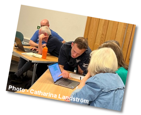
Community modelling gives local people an opportunity to make use of scientific computer modelling. It revolves around user-friendly computer interfaces, encouraging exploration of scientific models and data. Organised by local environmental groups, community modelling advances public engagement with water and aligns with the terminology of water science and decision making.
Catharina Landström,
Oxford University
Author
Catharina Landström ❐
Email
Project website
https://www.thames21.org.uk/community-modelling/ ❐
Details
The term 'community modelling' has several meanings. Here, we are talking about environmental groups using scientific modelling to explore concerning, local water issues. This activity revolves around computer interfaces that present model outputs in a format comprehensible to people without scientific modelling expertise. These interfaces let local people collectively analyse the physical mechanisms of urban water challenges and deliberate on physical and organisational interventions that could contribute to effective solutions.
Community modelling is a process performed in small groups. The computer interface is introduced by a person with previous experience of using it. Environmental non-governmental organisations (NGOs), such as rivers trusts, 'Friends of …' groups or local councils, can train interested people how to lead community modelling groups.
Community modelling comprises three sequential steps:
- using a computer interface to learn about the local water system
- exploring the relevant scientific modelling
- deliberating on what action to take
Firstly, it is important to learn about the local water system and its problems and consider the properties of the scientific model. A computer interface supports these actions through visualisations, with pop-up windows and text boxes explaining terminology and user controls. There are also links to further resources. The group will then explore the relevant scientific modelling by using maps and graphs in the computer interface to visualise processes in space and time and examine possible physical interventions that have been simulated in a model and could solve or mitigate the local water problem. Finally, the group will draw on their analysis of the physical system and the likely effects of interventions to decide on which actions to take. This is a starting point for planning how to actively contribute to local change.
These steps can be implemented in one or more workshop sessions, depending on participants’ pre-existing knowledge and the complexity of the water issue.
The Wetland Explorer (WE) is a computer interface developed for use in community modelling. It supports in-depth understanding of the potential of constructed wetlands to improve the water quality in local rivers. It was created in a collaborative process that emphasised the need to make lvisualisations and explanations of computer modelling comprehensible to people without extensive formal scientific training. Other research teams that want to develop similar tools for use by engaged publics should be aware that it is critical not to assume that images are self-explanatory or interpreted in the same way by everybody.
References
Landström, C, Becker, M, Odoni, N, and Whatmore, S J. 2019.
Community modelling: a technique for enhancing local capacity to engage with flood risk management.
Environmental Science & Policy, Vol. 92, 255–261.
DOI: 10.1016/j.envsci.2018.11.009 ❐